
Page 23 - Inside K&A Issue 2 - Aug 2016
P. 23
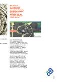
The Portal is
developed using
state-of-the-art
technologies including
ESRI ArcGIS, HTML5,
AngularJS and
Bootstrap with full
support to different
mobile devices.

Eng. Mohamed Khuzai,
the General Director of IT
Department, explained that this
portal includes all GIS information
related to projects and studies
inside Makkah Development
Authority such as the Makkah
Comprehensive Master Plan
Study and many more others.
The portal includes many services
that support the governmental
agencies' daily work and provides
many services to general users
such as allowing the users to
locate the Qibla direction and
the linear distance to the Holy
Kaaba from any location on
the map. Finally, the portal
will show the administrative
boundaries of Makkah region
and Haram borders and provide
the capabilities of searching for
different services inside Makkah.

                                     page
                                      23